| | |
| For general correspondence and membership matters, please click here. |
Synagogue services,
most functions,
Jewish Skills: Liberal Insights adult education programme. |
Community Rooms,
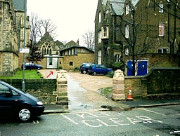
The red arrow points
to the Community Rooms |
Adjacent to
St. Mary's Church, Spensley Walk, Stoke Newington Church Street, (west of the intersection with Albion Road) London N16 9ES.
The Community Rooms are located at the end of a gravelled driveway which leads off Spensley Walk and Church Street Gardens.
[CLICK FOR STREET MAP]
The church which adjoins the venue has a very high steeple and is visible from a distance. It is situated opposite the south side of Clissold Park. Close by is the much smaller St Mary's Old Church which is situated within the park.
There is disabled access at the Community Rooms.
Occasionally our functions are held in other venues. Addresses (1) and (2) listed below are no more than about six minutes' walk from the Community Rooms:
- Abney Hall, 73a Stoke Newington Church Street, N16 0AS. Pedestrian access is via a passage next to Homa Restaurant which is at the corner of Kersley Street. [CLICK FOR STREET MAP]
- St Mary's Community Centre, Defoe Road, N16 0EP.
[CLICK FOR STREET MAP]
|
Please note there is NO PARKING ALLOWED in the St. Mary's Community Rooms driveway. There is limited street parking near the Community Rooms. Spensley Walk is "residents only" from 8.30am to 6.30pm Monday to Saturday.
Parking is generally free in the surrounding streets after 5.30pm Mon-Fri and after 1.30pm on Saturdays. The "Pay & Display" in surrounding streets remains the same.
Cyclists are welcome and there are off-street steel columns onto which you can lock your bike.
|
| Stoke Newington offers two "green routes" to our Shabbat services. So, if you are walking to shul then enjoy the expanse of Clissold Park. It contains a small zoo housing winged and four-legged creatures in pasture-like surroundings. Nearby you will find several acres of lush vegetation in Abney Park Cemetery. The latter is a Victorian garden cemetery and is now a designated local nature reserve and conservation area. You may prefer not to walk through a cemetery on Shabbat. |
| Nearest railway station: Stoke Newington BR station. (Liverpool Street - Enfield line). A few yards from the station entrance is a bus-stop: catch the 476 to the intersection of Albion Road and Stoke Newington Church Street and then walk 300 yards west. Alternatively you could walk there either on the pavements or through Abney Park Cemetery in under 20 minutes. |
| Nearest Underground station: Manor House station (Piccadilly Line). Catch any 141 or 341 bus heading south (downhill) along Green Lanes towards Newington Green. Alight at Stoke Newington Church Street and then walk along that street for about five minutes until you reach Spensley Walk. |
Nearby bus routes:
67 - runs between Wood Green and Aldgate. Alight at Abney Park Cemetery/Northwold Road, walk for about 12-15 minutes, west.
73 - runs between Stoke Newington Common and Victoria Station. Alight at intersection of Albion Road and Stoke Newington Church Street, walk 100 yards west.
141 - runs between Wood Green and London Bridge Station. Alight at intersection of Green Lanes and Stoke Newington Church Street, walk 300 yards east.
149 - runs between Edmonton Green and London Bridge Station. Alight at Abney Park Cemetery/Northwold Road, walk for about 12-15 minutes, west.
243 - runs between Wood Green and Waterloo. Alight at Abney Park Cemetery/Northwold Road, walk for about 12-15 minutes, west.
341 - runs between County Hall and Northumberland Park. Alight at intersection of Green Lanes and Stoke Newington Church Street, walk 300 yards east
393 - runs between Clapton (Nightingale Road) and Holloway (Nag's Head). Alight at intersection of Albion Road and Stoke Newington Church Street, walk 100 yards west.
476 - runs between Northumberland Park and Euston via Angel, Islington. Alight at intersection of Albion Road and Stoke Newington Church Street, walk 100 yards west.
|
| Designated roads which pass close by
to Stoke Newington Church Street and our venue in Spensley Walk are Green Lanes A105, Stoke Newington High Street A10, and Manor Road B105. |
